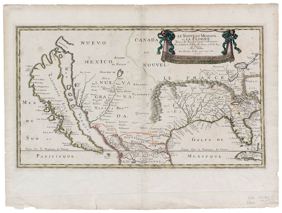
• Visit
    • Museum Gallery Map
    • What Our Visitors Are Saying
    • Accessibility >
      • Audio Tours
    • Upcoming Events
  • Exhibits
    • Current Exhibits
    • 3D Theater
    • Lightship Columbia >
      • Lightship Drydock Project 2021/2022
    • Warnock Model Boat Pond
    • Online Exhibits
    • Upcoming Exhibits
  • Education
    • Schools >
      • Field Trips >
        • Learning Labs
        • Self-Guided Visit
      • Museum in the Schools
      • Miniboat Program >
        • Miniboats in the News
    • Adult Education >
      • Classes
      • Groups
      • Lecture Series
      • Carving Club
    • Youth & Family >
      • Virtual Learning
  • Collections
    • Online Collections
  • Reference Library
  • Store
  • Join/Give
    • Individual/Family Memberships
    • Business Memberships
    • Planned Giving
    • Donate to Curatorial
    • Volunteer
    • Join Our Crew
  • Celebrating 50 Years of The QuarterDeck
Columbia River Maritime Museum
  • Visit
    • Museum Gallery Map
    • What Our Visitors Are Saying
    • Accessibility >
      • Audio Tours
    • Upcoming Events
  • Exhibits
    • Current Exhibits
    • 3D Theater
    • Lightship Columbia >
      • Lightship Drydock Project 2021/2022
    • Warnock Model Boat Pond
    • Online Exhibits
    • Upcoming Exhibits
  • Education
    • Schools >
      • Field Trips >
        • Learning Labs
        • Self-Guided Visit
      • Museum in the Schools
      • Miniboat Program >
        • Miniboats in the News
    • Adult Education >
      • Classes
      • Groups
      • Lecture Series
      • Carving Club
    • Youth & Family >
      • Virtual Learning
  • Collections
    • Online Collections
  • Reference Library
  • Store
  • Join/Give
    • Individual/Family Memberships
    • Business Memberships
    • Planned Giving
    • Donate to Curatorial
    • Volunteer
    • Join Our Crew
  • Celebrating 50 Years of The QuarterDeck
Picture
Nicolas Sanson
Le Nouveau Mexique, et La Floride
Paris 1656
Although not the first map to depict California as an island (the credit, or blame, for that persistent misconception goes to John Briggs's map published in London in 1625), this map is probably the more influential in that it was widely studied and copied throughout Europe.  This is the first map of any note to focus on Nouveau Mexique and the first map of the area to be produced on such a large scale.

New Mexican Indian tribes are identified along the R del Norte, or Rio Grande, mistakenly shown flowing southwest rather than southeast.  There are new place-names on the West Coast including, particularly, the peninsula Agubela de Cato jutting to the northwest above Californie Isle.  The north coast of the island of California depicted by Sanson with three "fingers" was widely copied by other European cartographers in addition to being perpetuated by many later editions of Sanson's own maps.

NEXT MAP

About

History
Board of Trustees
​Join Our Crew
Past QuarterDeck Issues
Volunteer
​Accessibility
​
​


Miniboats

Contact Us

Privacy Policy
© COPYRIGHT 2020. ALL RIGHTS RESERVED.
Picture
Picture
Picture
  • Visit
    • Museum Gallery Map
    • What Our Visitors Are Saying
    • Accessibility >
      • Audio Tours
    • Upcoming Events
  • Exhibits
    • Current Exhibits
    • 3D Theater
    • Lightship Columbia >
      • Lightship Drydock Project 2021/2022
    • Warnock Model Boat Pond
    • Online Exhibits
    • Upcoming Exhibits
  • Education
    • Schools >
      • Field Trips >
        • Learning Labs
        • Self-Guided Visit
      • Museum in the Schools
      • Miniboat Program >
        • Miniboats in the News
    • Adult Education >
      • Classes
      • Groups
      • Lecture Series
      • Carving Club
    • Youth & Family >
      • Virtual Learning
  • Collections
    • Online Collections
  • Reference Library
  • Store
  • Join/Give
    • Individual/Family Memberships
    • Business Memberships
    • Planned Giving
    • Donate to Curatorial
    • Volunteer
    • Join Our Crew
  • Celebrating 50 Years of The QuarterDeck