Didier Robert de Vaugondy
Carte de la Californie
Paris 1779
Carte de la Californie
Paris 1779
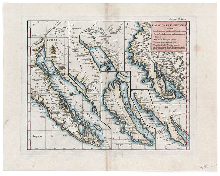
This map summarizes and displays five important versions of understandings, misunderstandings, and corrections in the mapping of California. This pictorial summary of the long-running confusion and controversy over California's status as island or peninsula was clearly intended to answer the question once and for all - as it did.
I. An Italian map by Mathieu Neron Pecci printed in Florence in 1604 and showing lower California as a peninsula, the coast north to C. de Fortuna and Cap. Blanco, with many other of Cabrillo's place-names and Quivira positioned between 35 degrees and 40 degrees latitudes (approximately the position of San Francisco Bay).
II. Nicolas Sanson's widely copied depiction of California as an island in 1656.
III. Guillaume de l'Isle's map of 1700 that essentially straddles the issue, leaving the observer to draw his own conclusions.
IV. Father Eusebio Kino's engraved map of 1705 clearly depicting the Colorado River being joined by the Gila River and entering the top of the Mer de la Californie, thus firmly restoring the depiction of California as a peninsula.
V. A fairly detailed Jesuit map drawn in 1767 and published by Vaugondy in 1779 in a compendium of ten maps of North America.
PREVIOUS MAP