Robert Sayer
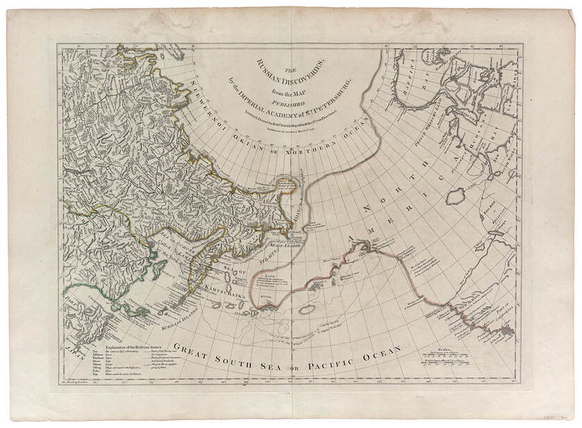
The Russian Discoveries, from the Map Published by the Imperial Academy of St. Petersburg
London 1775
The Russian Discoveries, from the Map Published by the Imperial Academy of St. Petersburg
London 1775
As the title suggests, this map is an English copy of a map recording Russian discoveries. In fact, it is a direct copy of a map made by Gerard Muller, a German cartographer working in Saint Petersburg. The Russians and the Spanish chose to keep their voyages of exploration secret. After the French cartographer Joseph-Nicolas de l'Isle had published his map of the so-called Discoveries of Admiral de Fonte (previous map), he was accused of stealing information from the Russians and indeed, it was he who first revealed to the world at large the general tracks of Bering in 1741 and Chirikov in 1740. Muller was officially encouraged by Russian authorities to construct his map in order to correct de l'Isle's mistakes, particularly those of the northwest coast of America. (11)
As on de l'Isle's map, Siberia and the Kamchatka Peninsula are shown in great detail. But Muller, unlike de l'Isle, shows the outline of Alaska with dotted lines suggesting the probable outline of the coast in relation to points actually touched by exploratory voyagers. Certainly this was a more scholarly and responsible approach. Note the reference, just north of 50 degrees N latitude, to Rio de los Reyes according to the pretended journal of Admiral de Fonte in 1640 according to Mr. de L'Isle.
The above notwithstanding, this map, too, is not without its own speculations. The River of the West is shown flowing west from Lake Winepegon to the Pacific Ocean at the Entrance discovered by Martin d'Aguilar in 1603 (the voyage that led to the belief that California was an island) to the north of New Albion and south of the suggested entrance to the Strait of Juan de Fuca. The persistent but mistaken belief in the existence of the River of the West encouraged many, including Thomas Jefferson, to speculate that a water route could be found from the American heartland west to the Pacific.
It is curious that, although the Kamchatka Peninsula and the Kuril Islands stretching to the south are portrayed relatively accurately, Japan and particularly the large northern island, now called Hokkaido, are not. Hokkaido is suggested by a group of islands with the legend The inhabitants of these islands are called Iesso by the Japanese. The main island of Honshu is shown in somewhat distorted form with the city Jedo (a version of Yedo, the ancient name for Tokyo) positioned at the head of what is now known as Tokyo Bay.
(11) Derek Hayes, Historical Atlas of the Pacific Northwest (Seattle, Sasquatch Press, 1999), 29.
PREVIOUS MAP