• Visit
    • Museum Gallery Map
    • What Our Visitors Are Saying
  • Exhibits
    • Current Exhibits
    • 3D Theater
    • Lightship Columbia
    • Warnock Model Boat Pond
    • Online Exhibits
    • Upcoming Exhibits
  • Education
    • Miniboat Program >
      • Miniboats in the News
    • Schools >
      • Field Trips >
        • Learning Labs
        • Lightship Sleepovers
        • Self-Guided Visit
      • Museum in the Schools
    • Adult Education >
      • Classes
      • Docent Led Tours
      • Lecture Series
      • Carving Club
    • Youth & Family
  • Collections
    • Online Collections
  • Reference Library
  • Store
  • Join/Give
    • Individual/Family Memberships
    • Business Memberships
    • Planned Giving
    • Donate to Curatorial
  • COVID-19 Protocols
  • Past QuarterDeck Issues
Columbia River Maritime Museum
  • Visit
    • Museum Gallery Map
    • What Our Visitors Are Saying
  • Exhibits
    • Current Exhibits
    • 3D Theater
    • Lightship Columbia
    • Warnock Model Boat Pond
    • Online Exhibits
    • Upcoming Exhibits
  • Education
    • Miniboat Program >
      • Miniboats in the News
    • Schools >
      • Field Trips >
        • Learning Labs
        • Lightship Sleepovers
        • Self-Guided Visit
      • Museum in the Schools
    • Adult Education >
      • Classes
      • Docent Led Tours
      • Lecture Series
      • Carving Club
    • Youth & Family
  • Collections
    • Online Collections
  • Reference Library
  • Store
  • Join/Give
    • Individual/Family Memberships
    • Business Memberships
    • Planned Giving
    • Donate to Curatorial
  • COVID-19 Protocols
  • Past QuarterDeck Issues
Picture
Giacomo Gastaldi
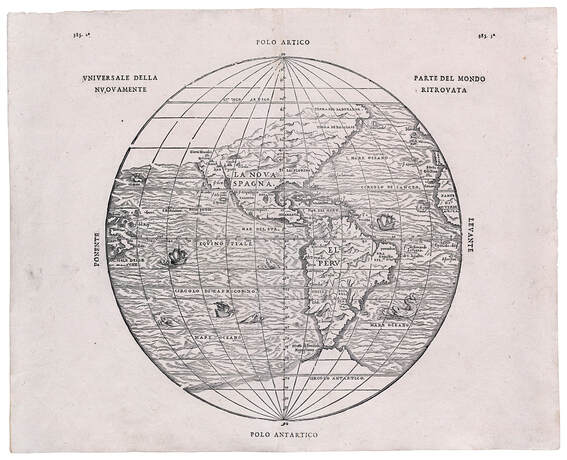
Universale della parte del mondo nuovamente ritrovata
​Venice 1565
The center of European cartography in the sixteenth century was Venice and its most important cartographer was Giacomo Gastaldi, believed to be the author of this map, which appeared in the compendium assembled by the well-known geographer Giovanni Ramusio.  The map was first drawn in 1556 but the woodblock was destroyed in a fire in the shop of the printer, Thomaso Guinti.  This map is a print of the second woodblock cut in 1565.

The Ramusio-Gastaldi map of the Western Hemisphere is unique as being the first printed map to show the place-names bestowed by Francisco Coronado in his exploration of the American Southwest between 1540 and 1542:  Quivira, Axa, Cucho, and Tiguas and the name Sierra Nevada resulting from Cabrillo's voyage up the West Coast in 1542-1544.  It is interesting to note how much the known portions of the Western Hemisphere have filled out and taken shape fairly accurately in the relatively short time between the Munster map (previous map) and this one.

About

History
Board of Trustees
​Join Our Crew
Past QuarterDeck Issues
Volunteer
​


Miniboats

Contact

Privacy Policy
© COPYRIGHT 2020. ALL RIGHTS RESERVED.
  • Visit
    • Museum Gallery Map
    • What Our Visitors Are Saying
  • Exhibits
    • Current Exhibits
    • 3D Theater
    • Lightship Columbia
    • Warnock Model Boat Pond
    • Online Exhibits
    • Upcoming Exhibits
  • Education
    • Miniboat Program >
      • Miniboats in the News
    • Schools >
      • Field Trips >
        • Learning Labs
        • Lightship Sleepovers
        • Self-Guided Visit
      • Museum in the Schools
    • Adult Education >
      • Classes
      • Docent Led Tours
      • Lecture Series
      • Carving Club
    • Youth & Family
  • Collections
    • Online Collections
  • Reference Library
  • Store
  • Join/Give
    • Individual/Family Memberships
    • Business Memberships
    • Planned Giving
    • Donate to Curatorial
  • COVID-19 Protocols
  • Past QuarterDeck Issues