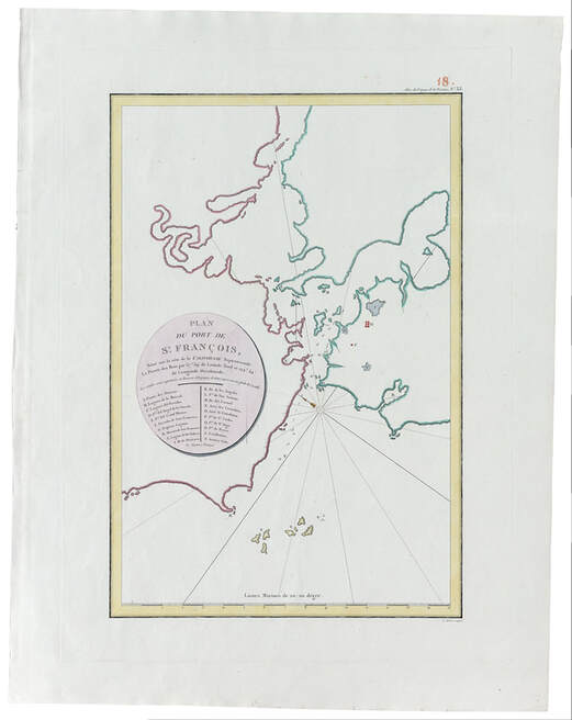
• Visit
    • Museum Gallery Map
    • What Our Visitors Are Saying
    • Accessibility >
      • Audio Tours
    • Upcoming Events
  • Exhibits
    • Current Exhibits
    • 3D Theater
    • Lightship Columbia >
      • Lightship Drydock Project 2021/2022
    • Warnock Model Boat Pond
    • Online Exhibits
    • Upcoming Exhibits
  • Education
    • Schools >
      • Field Trips >
        • Learning Labs
        • Self-Guided Visit
      • Museum in the Schools
      • Miniboat Program >
        • Miniboats in the News
    • Adult Education >
      • Classes
      • Groups
      • Lecture Series
      • Carving Club
    • Youth & Family >
      • Virtual Learning
  • Collections
    • Online Collections
  • Reference Library
  • Store
  • Join/Give
    • Individual/Family Memberships
    • Business Memberships
    • Planned Giving
    • Donate to Curatorial
    • Volunteer
    • Join Our Crew
  • Celebrating 50 Years of The QuarterDeck
Columbia River Maritime Museum
  • Visit
    • Museum Gallery Map
    • What Our Visitors Are Saying
    • Accessibility >
      • Audio Tours
    • Upcoming Events
  • Exhibits
    • Current Exhibits
    • 3D Theater
    • Lightship Columbia >
      • Lightship Drydock Project 2021/2022
    • Warnock Model Boat Pond
    • Online Exhibits
    • Upcoming Exhibits
  • Education
    • Schools >
      • Field Trips >
        • Learning Labs
        • Self-Guided Visit
      • Museum in the Schools
      • Miniboat Program >
        • Miniboats in the News
    • Adult Education >
      • Classes
      • Groups
      • Lecture Series
      • Carving Club
    • Youth & Family >
      • Virtual Learning
  • Collections
    • Online Collections
  • Reference Library
  • Store
  • Join/Give
    • Individual/Family Memberships
    • Business Memberships
    • Planned Giving
    • Donate to Curatorial
    • Volunteer
    • Join Our Crew
  • Celebrating 50 Years of The QuarterDeck
Picture
Comte de La Perouse
Plan de Port de St. Francois
Paris 1797
There are undoubtedly earlier Spanish maps, but because of the Spanish policy of secrecy referred to earlier, few were published and are, consequently, extremely rare.  This map, drawn by the comte de La Perouse as he worked his way south from Alaska in 1786, is one of the first published surveys of the San Francisco Bay.  It clearly shows the major topographical features that are so familiar today:  the Farrallones (S), Ile de Los Angeles (Angel Island) (K), Ile de Alcatraces (Alcatraz) (J), the Golden Gate (Q and D), the Presidio de San Fancisco (F), and the Mission de San Francisco (H).  With relatively minor adjustments, it would be possible to navigate today from the Pacific Ocean across the bay into San Pablo Bay and through the Carquinez Straits using only this chart.

About

History
Board of Trustees
​Join Our Crew
Past QuarterDeck Issues
Volunteer
​Accessibility
​
​


Miniboats

Contact Us

Privacy Policy
© COPYRIGHT 2020. ALL RIGHTS RESERVED.
Picture
Picture
Picture
  • Visit
    • Museum Gallery Map
    • What Our Visitors Are Saying
    • Accessibility >
      • Audio Tours
    • Upcoming Events
  • Exhibits
    • Current Exhibits
    • 3D Theater
    • Lightship Columbia >
      • Lightship Drydock Project 2021/2022
    • Warnock Model Boat Pond
    • Online Exhibits
    • Upcoming Exhibits
  • Education
    • Schools >
      • Field Trips >
        • Learning Labs
        • Self-Guided Visit
      • Museum in the Schools
      • Miniboat Program >
        • Miniboats in the News
    • Adult Education >
      • Classes
      • Groups
      • Lecture Series
      • Carving Club
    • Youth & Family >
      • Virtual Learning
  • Collections
    • Online Collections
  • Reference Library
  • Store
  • Join/Give
    • Individual/Family Memberships
    • Business Memberships
    • Planned Giving
    • Donate to Curatorial
    • Volunteer
    • Join Our Crew
  • Celebrating 50 Years of The QuarterDeck