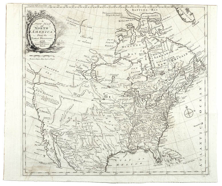
• Visit
    • Museum Gallery Map
    • What Our Visitors Are Saying
  • Exhibits
    • Current Exhibits
    • 3D Theater
    • Lightship Columbia
    • Warnock Model Boat Pond
    • Online Exhibits
    • Upcoming Exhibits
  • Education
    • Miniboat Program >
      • Miniboats in the News
    • Schools >
      • Field Trips >
        • Learning Labs
        • Lightship Sleepovers
        • Self-Guided Visit
      • Museum in the Schools
    • Adult Education >
      • Classes
      • Docent Led Tours
      • Lecture Series
      • Carving Club
    • Youth & Family
  • Collections
    • Online Collections
  • Reference Library
  • Store
  • Join/Give
    • Individual/Family Memberships
    • Business Memberships
    • Planned Giving
    • Donate to Curatorial
  • COVID-19 Protocols
  • Past QuarterDeck Issues
Columbia River Maritime Museum
  • Visit
    • Museum Gallery Map
    • What Our Visitors Are Saying
  • Exhibits
    • Current Exhibits
    • 3D Theater
    • Lightship Columbia
    • Warnock Model Boat Pond
    • Online Exhibits
    • Upcoming Exhibits
  • Education
    • Miniboat Program >
      • Miniboats in the News
    • Schools >
      • Field Trips >
        • Learning Labs
        • Lightship Sleepovers
        • Self-Guided Visit
      • Museum in the Schools
    • Adult Education >
      • Classes
      • Docent Led Tours
      • Lecture Series
      • Carving Club
    • Youth & Family
  • Collections
    • Online Collections
  • Reference Library
  • Store
  • Join/Give
    • Individual/Family Memberships
    • Business Memberships
    • Planned Giving
    • Donate to Curatorial
  • COVID-19 Protocols
  • Past QuarterDeck Issues
Picture
Jonathan Carver
A New Map of North America from the Latest Discoveries 1778
London 1778
Carver's frontispiece map clearly delineates the River of the West flowing unobstructed from the interior and emerging below as a representation of the Straits of Anian [sic] and the opening in the coast labeled Discovered by Juan de Fuca.  In the forward to his book, Carver writes of "the heads of four great rivers that take their rise within a few leagues of each other, nearly about the center of this continent; viz., The River Bourbon, which empties itself into Hudson's Bay, the Waters of the St. Lawrence, the Mississippi, and the River Oregon, or the River of the West, that falls into the Pacific Ocean at the straits of Annian [sic]."  This description, further elaborated on pages 76 and 77of the text, impressed on a wide audience the feasibility of finding a waterborne route linking the two great oceans, the Atlantic and the Pacific, through the interior of the continent.

About

History
Board of Trustees
​Join Our Crew
Past QuarterDeck Issues
Volunteer
​


Miniboats

Contact

Privacy Policy
© COPYRIGHT 2020. ALL RIGHTS RESERVED.
  • Visit
    • Museum Gallery Map
    • What Our Visitors Are Saying
  • Exhibits
    • Current Exhibits
    • 3D Theater
    • Lightship Columbia
    • Warnock Model Boat Pond
    • Online Exhibits
    • Upcoming Exhibits
  • Education
    • Miniboat Program >
      • Miniboats in the News
    • Schools >
      • Field Trips >
        • Learning Labs
        • Lightship Sleepovers
        • Self-Guided Visit
      • Museum in the Schools
    • Adult Education >
      • Classes
      • Docent Led Tours
      • Lecture Series
      • Carving Club
    • Youth & Family
  • Collections
    • Online Collections
  • Reference Library
  • Store
  • Join/Give
    • Individual/Family Memberships
    • Business Memberships
    • Planned Giving
    • Donate to Curatorial
  • COVID-19 Protocols
  • Past QuarterDeck Issues