• Visit
    • Museum Gallery Map
    • What Our Visitors Are Saying
  • Exhibits
    • Current Exhibits
    • 3D Theater
    • Lightship Columbia
    • Warnock Model Boat Pond
    • Online Exhibits
    • Upcoming Exhibits
  • Education
    • Miniboat Program >
      • Miniboats in the News
    • Schools >
      • Field Trips >
        • Learning Labs
        • Lightship Sleepovers
        • Self-Guided Visit
      • Museum in the Schools
    • Adult Education >
      • Classes
      • Docent Led Tours
      • Lecture Series
      • Carving Club
    • Youth & Family
  • Collections
    • Online Collections
  • Reference Library
  • Store
  • Join/Give
    • Individual/Family Memberships
    • Business Memberships
    • Planned Giving
    • Donate to Curatorial
  • COVID-19 Protocols
  • Past QuarterDeck Issues
Columbia River Maritime Museum
  • Visit
    • Museum Gallery Map
    • What Our Visitors Are Saying
  • Exhibits
    • Current Exhibits
    • 3D Theater
    • Lightship Columbia
    • Warnock Model Boat Pond
    • Online Exhibits
    • Upcoming Exhibits
  • Education
    • Miniboat Program >
      • Miniboats in the News
    • Schools >
      • Field Trips >
        • Learning Labs
        • Lightship Sleepovers
        • Self-Guided Visit
      • Museum in the Schools
    • Adult Education >
      • Classes
      • Docent Led Tours
      • Lecture Series
      • Carving Club
    • Youth & Family
  • Collections
    • Online Collections
  • Reference Library
  • Store
  • Join/Give
    • Individual/Family Memberships
    • Business Memberships
    • Planned Giving
    • Donate to Curatorial
  • COVID-19 Protocols
  • Past QuarterDeck Issues
Picture
Alexander Mackenzie
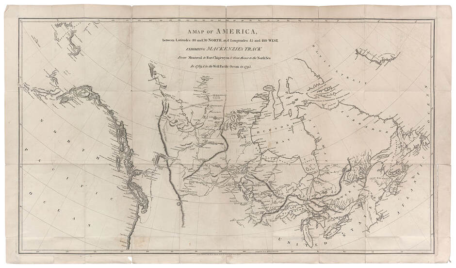
A Map of America, from Latitudes 40 and 70 North, and Longitudes 45 and 180 West, exhibiting Mackenzie's Track from Montreal to
Fort Chipewyan & from thence the North Sea in 1789 and to the West Pacific Ocean in 1793

London 1801
In 1789, from his headquarters at Fort Chipewyan on Lake Athabasca, Mackenzie set out journeying north up the Slave River, across the Slave Lake, and then northwest along what has since been known as Mackenzie's River, finally reaching the Arctic Sea.  Despite discovering and describing a route to the Arctic Sea and territory completely unknown to Europeans at the time, he was disappointed not to find the Pacific Ocean.  Resolving to try again, he set out in 1793 with one other European companion and a small band of Chippewa Indians.  This map shows their route west from Lake Athabasca to the Pacific.

About

History
Board of Trustees
​Join Our Crew
Past QuarterDeck Issues
Volunteer
​


Miniboats

Contact

Privacy Policy
© COPYRIGHT 2020. ALL RIGHTS RESERVED.
  • Visit
    • Museum Gallery Map
    • What Our Visitors Are Saying
  • Exhibits
    • Current Exhibits
    • 3D Theater
    • Lightship Columbia
    • Warnock Model Boat Pond
    • Online Exhibits
    • Upcoming Exhibits
  • Education
    • Miniboat Program >
      • Miniboats in the News
    • Schools >
      • Field Trips >
        • Learning Labs
        • Lightship Sleepovers
        • Self-Guided Visit
      • Museum in the Schools
    • Adult Education >
      • Classes
      • Docent Led Tours
      • Lecture Series
      • Carving Club
    • Youth & Family
  • Collections
    • Online Collections
  • Reference Library
  • Store
  • Join/Give
    • Individual/Family Memberships
    • Business Memberships
    • Planned Giving
    • Donate to Curatorial
  • COVID-19 Protocols
  • Past QuarterDeck Issues